
Cloud Provinces
A cloud province may be defined as a limited territory over the world ocean (and sometimes over parts of the coast).
It is characterized by a cloud picture which is specific for it and probably depends on the season.
A cloud picture may be represented by one or several interacting cloud structures.
Some cloud provinces have similar cloud pictures, and some have unique ones, typycal only for them.
Some of the cloud pictures that can be found over the ocean are as follows:
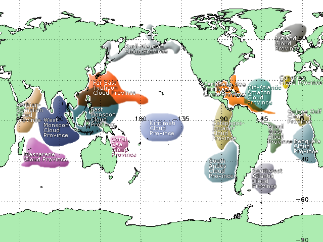
• Kiritimati Cloud Province
The province is situated above the centre the Pacific close to Kiritimati Island.
It contains almost exclusively “Peacock Feather Looking” CS (with seasonally-dependent intensity) and “Convection Streets” CS.
It is shaped by constant east wind and water temperatures.
• Galápagos-Ecuador Cloud Province
The province spreads from Pacific coast of Central America to ca. 20°S latitude. It is bordered from the east side by the coast of Colombia, Ecuador and north Peru and from the west side to ca. 105°W longitude.
The season-dependent cloud picture consists of the clouds (from north to south) of “Mesoscale Convective” system, “Convection Streets” CS and prolonged "Close Convective Cells" CS.
It is shaped by Humboldt Current, by the wind around Pariñas Point and also highland coast.
• Coral Sear Cloud Province
The province is situated over Coral Sea, close to northeast Australian coast.
In this area wind and sea current come from southeast.
The clouds, mainly "Travelling Convective Cells" CS, emerge season-conditionally (particularly in there spring time) within the area between New Zealand and Fiji and move in northwest direction to Australia, where over Great Dividing Range dissolve.
• East Monsoon Cloud Province
The province is situated over Pacific east of Indochina and it is bordered from the east side by the ca. 150° E longitude (western Micronesia), from the north side by Taiwan Island, from the south side - by Lesser Sunda Islands.
The seasonally cloud picture mostly consists of “Cloud Torch” CS and “Outflow Boundary” CS and depends on monsoon wind.
examples: | 1 | 2 | 3 | 4 |
• West Monsoon Cloud Province
The province is in the west of Indochina Peninsula over Andaman Sea, Gulf of Bengal and centre of Indian ocean to ca. 70°E longitude (over the east of Arabian Sea); it is bordered from the north side by the Asia coast and from the south one - by 15°-18°S latitude.
The cloud picture mostly consists of “Cloud Torch” CS and “Outflow Boundary” CS and seasonally depends on monsoon wind.
examples: | 1 | 2 | 3 | 4 | 5 | 6 | 7 |
• Arabian-Somalian Cloud Province
The province is very interesting. It is situated over western and central parts of the Arabian Sea and over the western part of the Indian Ocean between Africa coast and Seychelles.
The "Convective Close Cells" CS are season-conditionally (in the summer months) observed here (not particularly expecting, but possibly caused by the relatively cold water).
In the late summer and autumn, the very impression “Convection Streets” CS are here observed, which is caused by monsoon fringe.
example: | 1 | 2 | 3 | 4 | 5 | 6 | 7 |
• Mascarene Cloud Province
The province contains nearly the whole year the clouds of "Travelling Convective Cells" CS (and some different one).
It is situated over Mascaren islands and is bordered from the east side by 100°E, and from 15°S to 35°S latitude - from the north and south side accordingly.
Here normally blows the eastern wind. The sea current comes also from the east.
• Kuril-Aleutian Cloud Province
The province is situated over the north part of Pacific: Sea of Okhotsk, Kuril Island, Aleut Island, Gulf of Alaska and Bering Sea.
The strong meridional cold wind blows there in the late spring, and it cause clouds of “Karman Vortex” CS.
The “Ship Trails” CS and “Convective Cells Streets” Phenomenon can be also observed there.
• Far East Typhoon Cloud Province
In the province typhoons are observed in the late summer and in the autumn.
example: | 1 | 2 | 3 | 4 | 5 | 6 | 7 | 8 |
• Caribbean Sea Hurricane Cloud Province
In the province hurricanes are observed in the late summer and in the autumn.
example: | 1 | 2 | 3 | 4 | 5 |
• Canarias Cloud Province
The province is situated over Madeira Islands, Canarias Island and spreads 200-300 km more in the south direction.
The wind, which blows here from the north, often causes “Karman Vortex” CS.
example: | 1 | 2 | 3 | 4 | 5 | 6 | 7 |
• Guinea Gulf Cloud Province
The province is situated over the Gulf of Guinea.
The season-dependent cloud picture reminds here of another one, which is to be observed in northern part of Galápagos Ecuador CP: the clouds of “Mesoscale Convective” System and “Convection Streets” CS, which is caused by warm sea surface temperature and by northern, from the African coast flowing wind.
example: | 1 | 2 | 3 | 4 | 5 |
• Benguela Cloud Province
The province is situated over south Atlantic, close to the southwest of the African coast. It is bordered from the west side by 15°W longitude.
The cold Benguella current and the warm wind from the continent causes here one of the largest atmosphere field of “Convective Cells” CS (at most “Close Cells” CS).
The “Cutting” Phenomenon, the “Wave over” Phenomenon and “Actinoform” CS can be observed here.
At the southern edge of this province the “Open Cells” CS are often to be seen.
The province resembles the South Andes CP.
• South Andes Cloud Province
The province is situated over south Pacific, close to south Peruvian coast and Chilean coast. It is bordered from the west side by 110°W longitude, by the south - by 45°-50°S latitude.
The cold Humboldt sea current, the height mountainous coast and the wind from Andes cause here the world largest accumulation of clouds of “Convective Close Cells” CS.
The large fields of “Actinoform” CS could be season-dependently observed here. From the south of this province the clouds of “Convective Open Cells” CS come very often.
The province is a source of “Travelling Convective Cells” CS.
It resembles the Benguela CP.
• Mid-Atlantic Amazon Cloud Province
The province is situated over the centre of Atlantic, in the rectangle [30°N-10°N], [60°W-40°W]. It is appropriate in the east of Caribbean Sea and in the north of the north coast of Brazil.
The season-dependent (in the spring) cloud picture has here a singular mega structure of “Travelling Convective Cells” CS, which lay more or less in regular knots of a net and are in last decay phase.
example: | 1 | 2 | 3 | 4 | 5 | 6 |
• Brazil West Cloud Province
The province is situated over Atlantic in the east of the east coast of Brazil.
The cloud picture is here represented by a singular mixture of “Travelling Convective Cells” CS, of “Actinoform” CS and not rare of “Cloud Arc” CS.
example: | 1 | 2 | 3 | 4 | 5 | 6 | 7 | 8 | 9 |
• Southwest Atlantic Cloud Province
The province is situated over south Atlantic close to Argentine coast. From the east side it is boarded by 30°W longitude.
The “Extra tropical Cyclone” CS and “Gravity Waves“ CS are often to be observed here.
example: | 1 | 2 | 3 | 4 |
• Iceland Cloud Province
The province is situated over Iceland in the north Atlantic.
It is the source of “Extra tropical Cyclone” CS, which strongly affects the European climate.
example: | 1 | 2 | 3 | 4 |
|
