"Convective Cells"
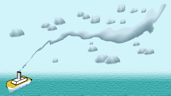
"Ship Trails" Cloud Structure (STS)
 "Ship trails" cloud structure consists of stratocumulus (and at its edge
of low cumulus) cloud lines.
"Ship trails" cloud structure consists of stratocumulus (and at its edge
of low cumulus) cloud lines.
Clouds of this structure, embedded in a layer of small and low stratus
and stratocumulus clouds (which build a convective cells structure), can
be observed above a sea areas.
The dimension of such cloud lines reaches as much as 30
km width (sometimes up to 50 km) and up to 1000 km (and more) length.
Cloud top height does not exceed the height of 1-2km, and the albedo is
in the range 0.3-0.6.
It is supposed that this structure has an artificial origin,
because it is connected with the navigation of vessels.
In the image of visible range it has the higher brightness than the surrounding
low clouds, however it can not be recognized in the infrared picture,
because the cloud top height are low.
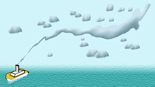
The moving ships give off the fine particles (also called aerosols) and
warm exhaust steam.
In a cool and humid atmospheric layer, which is connected with a high-pressure
system, these particles become a condensation nucleus of clouds, absorb
the humidity and produce the bright clouds. Those consist of the small
droplets.
The small droplets reflect more lights (within the visible range) than
large droplets, therefore the clouds of "Ship trails" structure have the
higher brightness than the surrounding convective cells clouds.
However within the infrared range they can be only badly recognized, because
the cloud top height is low and accordingly warm.
The "Ship trails" cloud structure can be observed mostly
over North Pacific (close to the west coast of the USA, Aleuts, Kamchatka
and northeast coast of Japan) as well as over North Atlantic (west coast
of Europe, east coast of Newfoundland), rarely - not far from the Peruvian
and Chile coast, coast of Namibia, Tasman Sea.
|