"Convection Streets" Cloud Structure (CSCS)
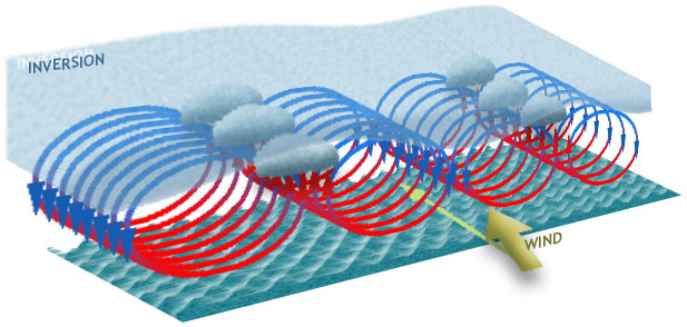
 If in the ground flowing humid air, which is covered with approx. 1.5-2 km high lying inversion layer, turbulent movements appear, then the cloud streets can form into this air. If in the ground flowing humid air, which is covered with approx. 1.5-2 km high lying inversion layer, turbulent movements appear, then the cloud streets can form into this air.
They are called “convective streets”, because they are parallel to each other and to the wind direction.
They are only 1-3 km wide, but they can reach the length up to several hundred kilometres.
The emergence of “cloud streets” happened often if the higher air sinks, like e.g. possibly at the high pressure of area (anticyclone) or during the nocturnal ground fog.
The circulations are formed under a sinking inversion layer, as one follow of moderate and strong wind flowing in almost constant direction.
If the wind speed increases from the ground to the inversion layer up to 10 m/s and the air humidity is sufficient for the condensation, then cumulus (and stratocumulus) clouds can develop in rising and therefore cooled down air of the circulations and move along the resulting convergence lines.
The circulating air masses have the form of little flattened cylinders, whose adjustment deviates from the wind direction.
The horizontal distance between the streets corresponds in ideal case to the triple height of inversion layer (in reality 3N-times, where N = 1, 2, 3)
Should the inversion layer be not a very stable, the stronger convective clouds form along the lines and the street can branch out on corresponding places, so that it looks from above as a sea-grass. It can be some more thickly (up to 5-7 km) and longer (to 1000 km and more).
The “cloud streets” are observed normally in masses, particularly in the centre of the Pacific in Kiritimati (Christmas Island) area (so-called "Kiritimati Cloud Province") and in/around Arab sea.
In addition, they can be seen above the north path of the Indian Ocean, in/around Gulf of Bengal and above the west part of Pacific.
In the form of sea-grass, which is frequently affected by a land neighbourhood, the “cloud streets” can be observed above the water around east and north of Australia (among them “Morning Glory Cloud Structure”), above Gulf of Guinea and above east Pacific close to the Central American coast.
In addition, above West Atlantic and east of the Indian Ocean they are to be seen season-conditioned.
The cloud line can appear also as an individual line. Then it marks a convergence zone, where warm air rises upward.
The origin can be different. For example, they can be not rare observed as land breezes clouds, and then they form a curve around some islands or coastal regions.
Generally, they appear within ±30° band from Equator, in most cases even within ±15°.
This is a spreading type of the cloud structure.
It is also often observed above the land.
There are cloud street structures, which have the same emergence, but form in middle latitude under strong cold flowing wind above relatively warm water.
They develop as blowing out close & open cells. They are not considered here, but with “the Convective Cells Structures” part.
Not rare the “cloud streets” structure is observed with the other round-like cloud structure.
It could be found in the Kiritimati Cloud Province: above the rectangle with coordinates approx. (5°N - 15°S; 130°W-180°W). |