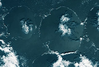
"Cloud Arc" Structure (CAS)
 The structure called "Cloud Arc" looks from above with optimal conditions
(there is hardly cross-wind) circular or oval.
The structure called "Cloud Arc" looks from above with optimal conditions
(there is hardly cross-wind) circular or oval.
There is more highly lying cloud mass in the centre of the very narrow
circle belts of cumulus and stratocumulus. It consists of stratus and
altostratus radial moved clouds, which are bordered from stratocumulus
clouds.
The luff side very often disappears (or is squeezed along the wind direction)
and the cloud form of the centre shifts to the lee side.
It can be also "Cloud Arc" structures observed, where there are no clouds
insides; then only empty circles is seen.
These structures are not rare observed as a group of two,
three and more circles.
Also there are cases, where circles (often empties) fuse and form a chain
from some cells (it looks as a chain) along the wind direction.
The size of this structure is from 15 km (the smaller one
was not noticed because of the resolution of satellite images) up to 250
km and more.
The Cloud top height of the circular belts is 1.5-2.5 km;
The Cloud top height the interior clouds is 3-3,5 (sometimes to 4,5) km.
The albedo of the centre section is 0.5-0.9.
The structure emerges normally within +-30° latitude
- above central and west Pacific,
- above west Atlantic,
- above Indian ocean usually in the south of equator.
This structure is to be observed not seldom.
It can be assumed, that it develops still more frequently, but the narrow
belt releases fast and only the interior clouds remain.
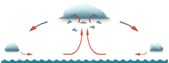
The interior clouds are thicker than the others; they are
located within a vertical convective flow and rise close to the centre
of the circle upward.
While air rises to inversion layer, it spreads horizontal in all directions,
until it finally cools and sinks down back to the sea surface.
This process pushes all existing small cumulus clouds away of the central
region of convection. In addition if air sinks, it warms and prevents
the forming of other small clouds. Therefore the area within the circle
is kept cloudless.
The horizontal flow of sinking air becomes rather weaker on the circle
border. It will be influenced of central rising flow. Air moves towards
the centre now, where it can rise again, perhaps, supporting of the new
quantity of the small cumulus clouds.
It is interesting to observe the form of the sea surface
under the "Cloud Arc" structure.
If this structure lies in a sun glint area for the satellite point of
view, the brighter lighting of the sea surface from the sun side is seen,
so it looks that the water surface which is under the structure would
raise a little.
The phenomenon could be explained as follows. The deeply flowing wind
is stronger near to the centre of "Cloud Arc" cell. It produces the waves,
which reflect the sun light less.
From the other side the water surface could be really sucked upward with
the air, which rises in the centre of the cell. The sea surfase rises
by a very small amount so, that it can be noticed.
|