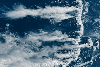
"Outflow Boundary" Structure (OBS)
(A shelf cloud)
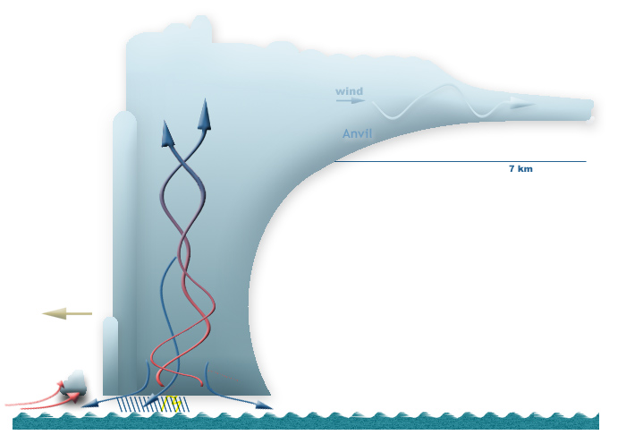 Warm
air rises up at the border of warm-humid and cold air masses flowing one
to the other. Therefore it is cooled down, which leads to the condensation. Warm
air rises up at the border of warm-humid and cold air masses flowing one
to the other. Therefore it is cooled down, which leads to the condensation.
So formed clouds are often seen from a satellite as a narrow circle, an
arc, a ring segment or a sickle.
They consist mostly of deeper cumulus, stratus and stratocumulus clouds
however its albedo can be high enough (up to 0.8).
Cloud top height: 1-2 km.
A part of the regarded cloud structures is connected with
large more-cellular thunderclouds, which were called as
"Cloud Torch" Structures.
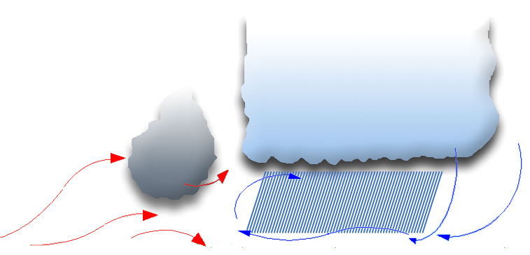
"Outflow Boundary" structures look as a sickle, in whose back part even
nimbostratus and (more rarely) altostratus clouds can emerge.
This shape moves in front of the "Cloud Torch" structure to the same wind
direction and either connects with it or has a distance up to 25 km.
Outflow boundary develops if a cold front that is connected
with the low pressure area or large thunderstorm cell (general: Mesoscale
Convective system) penetrates wedge-like into the offshore warm sector.
 If
in a convective cloud system rainfall (or even hail) begins, the against-flowing
warm upwind is cooled down and turns over downward, which leads to the
accumulation of cool air in the near-surface volume. If
in a convective cloud system rainfall (or even hail) begins, the against-flowing
warm upwind is cooled down and turns over downward, which leads to the
accumulation of cool air in the near-surface volume.
This layer of cool air moves in front and together with the convective
system (e.g. thunderstorm cell cluster) and raises there warm-humid air,
which flowed towards the thundercloud, whereby the typical "arcus clouds"
emerge. They can be recognized on the satellite images more frequently
as a "shelf clouds".
The further the clouds far away from the front of the "outflow boundary"
structure are (however within the structure), the more largely their cloud
top height is: from 1 km to 3.5 km; sometimes more.
The sickle-like structures can not rare form also without
thunderstorm cells.
In this case they are narrower and smaller and appear in groups, chain-like.
In such way they can mark the movement of cool air mass.
The "Outflow Boundary" cloud structure is normally
observed within a zone ±30° by the equator.
In addition, at the west coast of some continents, where the convective
cells cloud can be discovered much more frequently, e.g. over west and
Pacific, northeast of the Indian ocean. It appears offshore there.
|