"Convective Cells"
'Open Cell' Structure (OCS) & 'Enhanced Cumulus' Structure (ECS)
 An
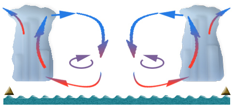
open cell consists of convective clouds, which top reaches only the lower
layers of the troposphere. An
open cell consists of convective clouds, which top reaches only the lower
layers of the troposphere.
Within the cell vertical circulation takes place: the streams of the air
go up in the zone close to its vertical borders (the cell sides) and then
go down in an "empty place" (in the middle of the cell where there are
almost no clouds).
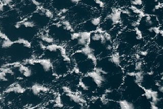
Seen from above, an open cell ideally looks like a hexagon with the sides
formed by rising clouds.
However, a separate cell can be found quite seldom; they usually make
up fields that ideally look (from above) like honeycomb and in reality
resemble chain amour.
The size of a cell is up to 70 km (not rarely up to 100 km).
The cloud top height of an open cell is 1.5-2.5 km, (sometimes up to 3
km).
The cloud top height of Enhanced Cumulus Clouds is up to 4-6 km, (rather
often up to 7 km).
Accordingly albedo increases from ~0.5 to ~0.8 (and even to 0.85).
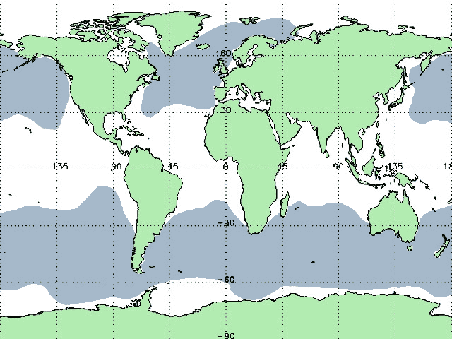
Space pictures often enable to see open and close cells sharing one and
the same cloud field.
Open cells are present in convection cells cloud streets that in most
cases emerge as the result of strong cold wind blowing over polar seas.
The Enhanced Cumulus Clouds represent a particular kind
of the open sells.
They form above polar seas and seas in the middle latitudes as the season
may be.
The cold air moving over the sea surface heats from below as its temperature
is lower than that one of the water. As the result of this heating there
appears instability in the surrounding atmosphere and the warm masses
of the air go up, cooling.
The condensation goes with the release of latent heat that holds the vertical
streams. Owing to the cooling of the air that is being raised this support
is accompanied with the enhancement of condensation.
From the upper layers of the atmosphere the cold dry air is going down
towards the rising stream. That is why the movement upward is limited
in the convective cells and in some time there appears the balance between
the rising and descending streams of the air. As the result large fields
of cold cells emerge often causing a great amount of precipitation.
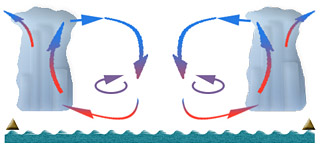
In the upper level of outlet channel inside cold air masses following
the cold front under strong wind caused by the instability in the atmosphere
the sides of the cell perpendicular to the direction of the wind become
higher and (when seen from above) thicker. Not seldom such an effect occurs
in the cold areas on the backside of large cyclone swirls.
|