"Mesoscale Convective" System (MCS)
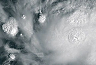
 Type "Mesoscale Convective system" looks on satellite images as a circle,
an oval, sometimes disorderly, but always compact.
Type "Mesoscale Convective system" looks on satellite images as a circle,
an oval, sometimes disorderly, but always compact.
It consists of high cloud forms, to whose mostly belong cumulonimbus clouds,
but also cirrostratus and (at the edge) altostratus clouds.
Its size is from 20-40km (for the single thunderstorm) up to several hundreds
(up to ca. 200-400km), even thousand kilometres and extents its surface
up to half million square kilometres.
The cloud top height reaches 13-15 km, sometimes up to 16km.
The albedo is in the range 0.8-0.95 (up to 1.0).
It can be emerged
- above the Tropics, in the latitude band from -15° to +15°
von Equator,
- above the northern part of the Indian ocean,
- close to the eastern coastal regions from North America and Asia
in the latitude of 40°-45° N,
- more rarely close to the eastern coastal regions of South America,
Madagascar and Australia,
- above Samoa - Cook Island area
This is spreading type.
To the "Mesoscale Convective system" belong also "Cloud
Clusters", "Squall Lines" and mainly the "Circular Cloud Areas", which
are accompanied with a Hurricane or a Typhoon. The last one will be described
in the separate article.
The structures of this type will observed also over the
land between the latitudes of 40°N and 40°S.
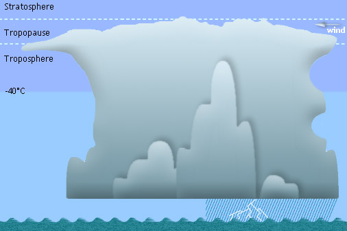
If warm air rises above the cooler one, it begins to cool
down and the water vapour condenses as water droplets. This condensation
causes the heating of surrounding air and thus the continuation of its
rising.
The water vapour cools in the height and forms more water droplets and
also the ice crystals, which begin to fall. This downward movement competes
with the upward one.
The Mesoscale Convective system is a complex of thunderstorm clouds, which
is much larger than the single thunderstorm, and exists normally longer
than one day. It consists of convective clouds of the different sizes
and at the different development phase and it emerges over the Tropics,
where water and air temperature produce sufficient moisture and powerful
vertical flows.
The cumulonimbus clouds mentioned in the system can grow up to tropopause.
The Mesoscale Convective system is connected with the low pressure areas
and its clouds cause heavy rainfalls, thunderstorms and hail.
|