Supraglacial lakes of Western Greenland
Avannaata municipality | Eastern Greenland
Dates of acquisition:
- August 21st, 2023 | 20:09:54 UTC
- August 27th, 2023 | 15:33:18 UTC
Sensor: Sentinel-2A L2A
Coordinates: ca. 70.43511°N, 49.46109°W
Since the early 1990s, the amount of meltwater on the Greenland ice sheet has increased dramatically due to rising air temperatures caused by global warming and darkening of the ice surface. Every year in midsummer, as the weather warms, bright blue melt-water lakes can be seen on the ice surface, forming in topographic depressions in the ice. This usually occurs in the ablation zone of an ice sheet moving towards the ocean. [In glaciology, ablation is the reduction in mass of a glacier due to melting, evaporation and mechanical removal (e.g. by wind drift) or destruction (e.g. iceberg break-up).] In summer the movement of the ice sheet accelerates; in winter it slows down but does not stop completely. The number of supraglacial lakes in Western Greenland reaches 2-3 hundred. The lakes vary in size (from a few meters to several tens of kilometers across) and depth (up to 10 meters), and appear in different shades of blue and turquoise in satellite images. The darker the blue, the deeper the lake. The lakes are usually at their largest in August.
These supraglacial lakes store large amounts of fresh water throughout the season, lasting for weeks, months or even years, but sometimes disappearing suddenly and rapidly, within a few hours. If the movement of the ice sheet opens a crack in the ice at the bottom of the lake, the water can quickly escape, leaving behind only a gaping funnel on the ice surface. Thus, entire lakes can be drained in a short period of time.
This is done by a process called hydrofracturing. A stream emerging from the lake drains water into a mill – a channel that connects the surface to the base of the ice sheet hundreds of meters below – which directs meltwater to the base of the ice sheet. Water accumulates between the bedrock and the base of the ice sheet and “lubricates” the interface between the ice and the bedrock, allowing the ice sheet to slide faster towards the coast.
As mentioned above, there are many lakes that exist for years and freeze partially or completely in winter and thaw in summer. Infrared data shows that liquid water can persist in lakes under ice throughout the winter. Ice shifts or low temperatures in winter can seal and cork some of the glacial mills allowing the “dry” lake to be refilled with melt water in the next season.
In Figure 1 a Sentinel-2 image is presented, showing of a group of supraglacial lakes in western Greenland in the area near the base of the Nuussuaq Peninsula and the source of Store Glacier, which flows into the Qarajaq Isfjord north of Nuussuaq.
The largest lake (in Fig. 1, top left, in the form of the Greek letter Δ) is located at 70.43511°N, 49.46109°W at an altitude of approximately 365-380 metres. At its widest, it has a perimeter of about 11 kilometers. It is four times the size of the Außenalster in Hamburg and more than twice the size of Central Park in New York.
Images of this region since 2017 are shown in Figure 2. Each year, the lakes of the region are presented on the day when they are largest (be aware that the lakes are not visible on many cloudy days). It can be seen that the size of the lakes varies largely from year to year, but they do not disappear completely. In summer, as more melt water flows into the lake and there is still ice on the surface, the water level rises, tearing this ice away from the ice “shore”. This explains the ring structures where the melt water is only visible at the edge of the lake.
A little to the west of this group of lakes, at the foot of Store Glacier, a small lake can be observed which shape resembles a crescent moon (70. 47711°N, 50.27202°W). Its dimensions are ~(1.9 x 1) km, the surface area is ~1.6 km2. According to Sentinel-2 observations from 2017 (Figure 3 , animation) and taking into account “Landsat 1-5 MSS“ data Collection since 1983, it can be assumed that this lake has existed at this place for at least 40 years, without any noticeable change in its location and shape (at least when it can be observed from satellites). This leads to the cautiously assumption that the surface velocity of the Store Glacier in this location is minimal.
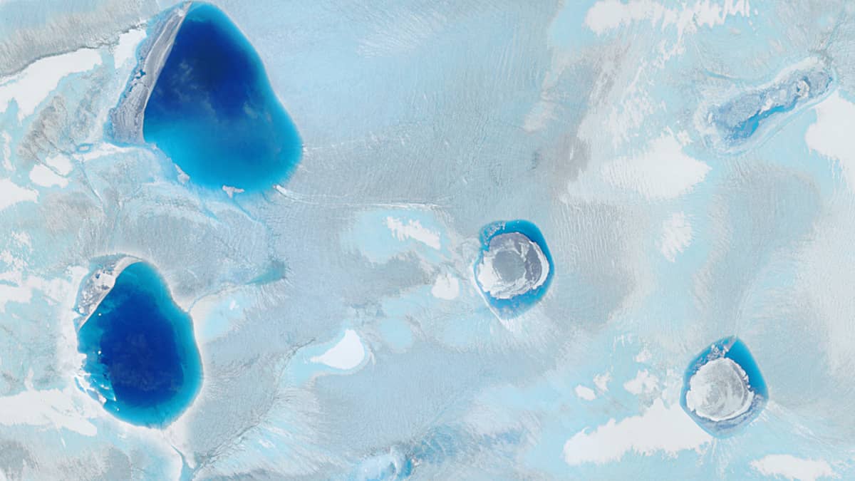
A similar situation occurs with supraglacial lakes in the body of Ryder Glacier in North Greenland (Figure 4). The shape of the lakes at their maximum extent is shown as yellow outlines. It can be clearly seen that their absolute position does not change.
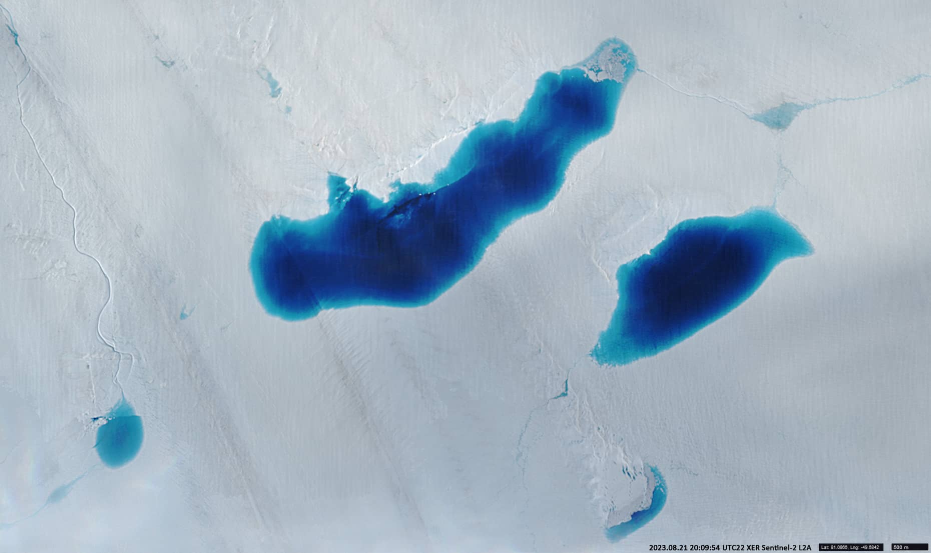
The length of the elongated supraglacial lake (Figure 5; 81.0866°N, 49.6842°W) at the base of the Ryder glacier is ~6 km; the surface area is ~7.2 km2.
Fig. 1
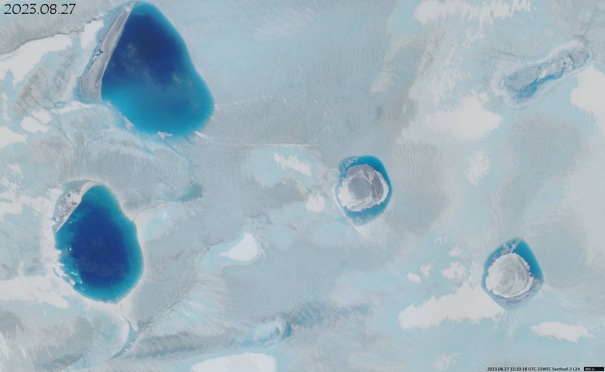
Fig. 2
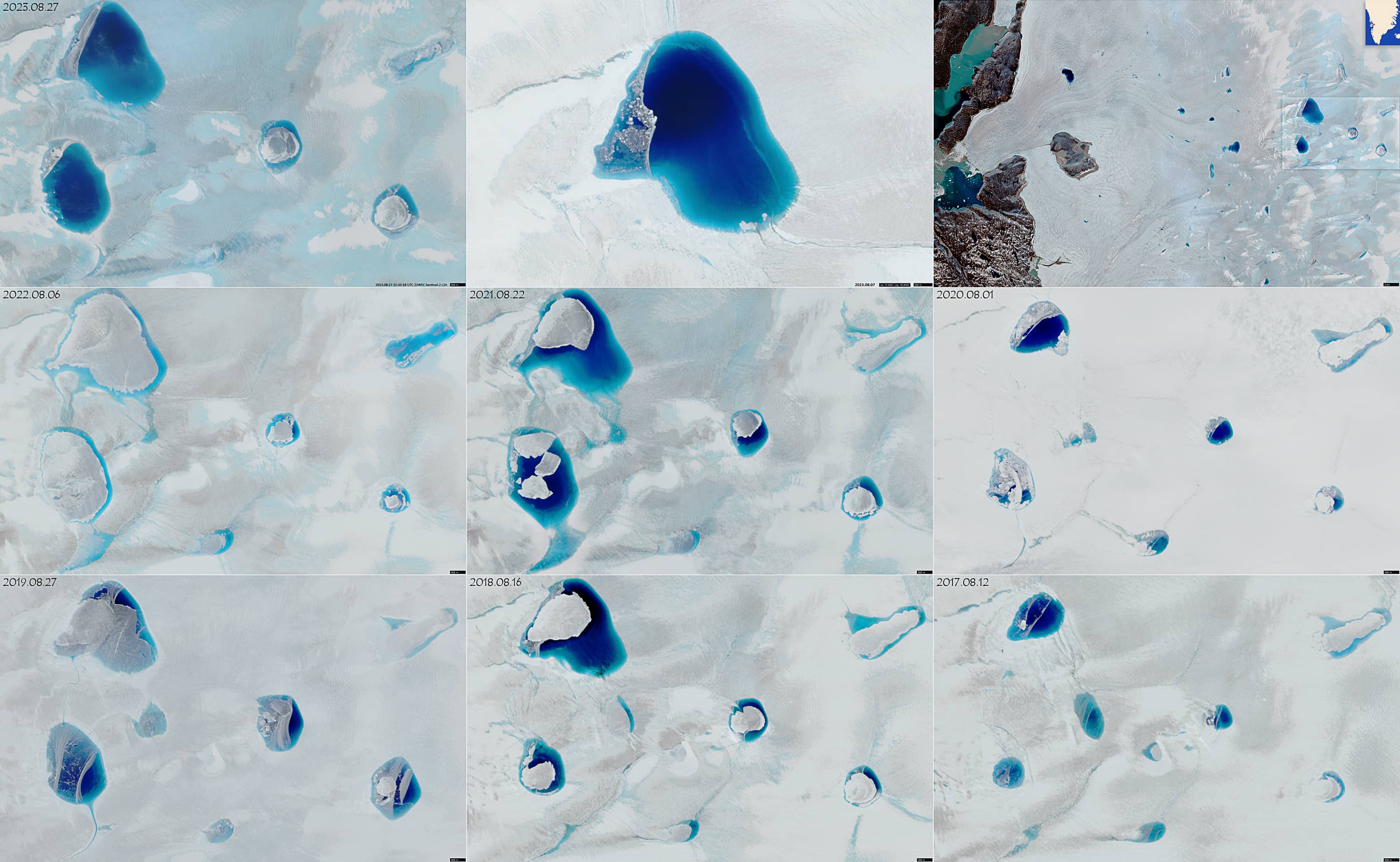
Fig. 3
Fig. 4
Fig. 5