Ridley Beach in Antarctica
Victoria Land | East Antarctica
Date of acquisition: February 1st, 2024 | 21:26:00 UTC
Sensor: Sentinel-2B L2A
Coordinates: ca. 71.31°S, 170.19°E
The article shows how many stories can be told about a small piece of land at the end of the world.
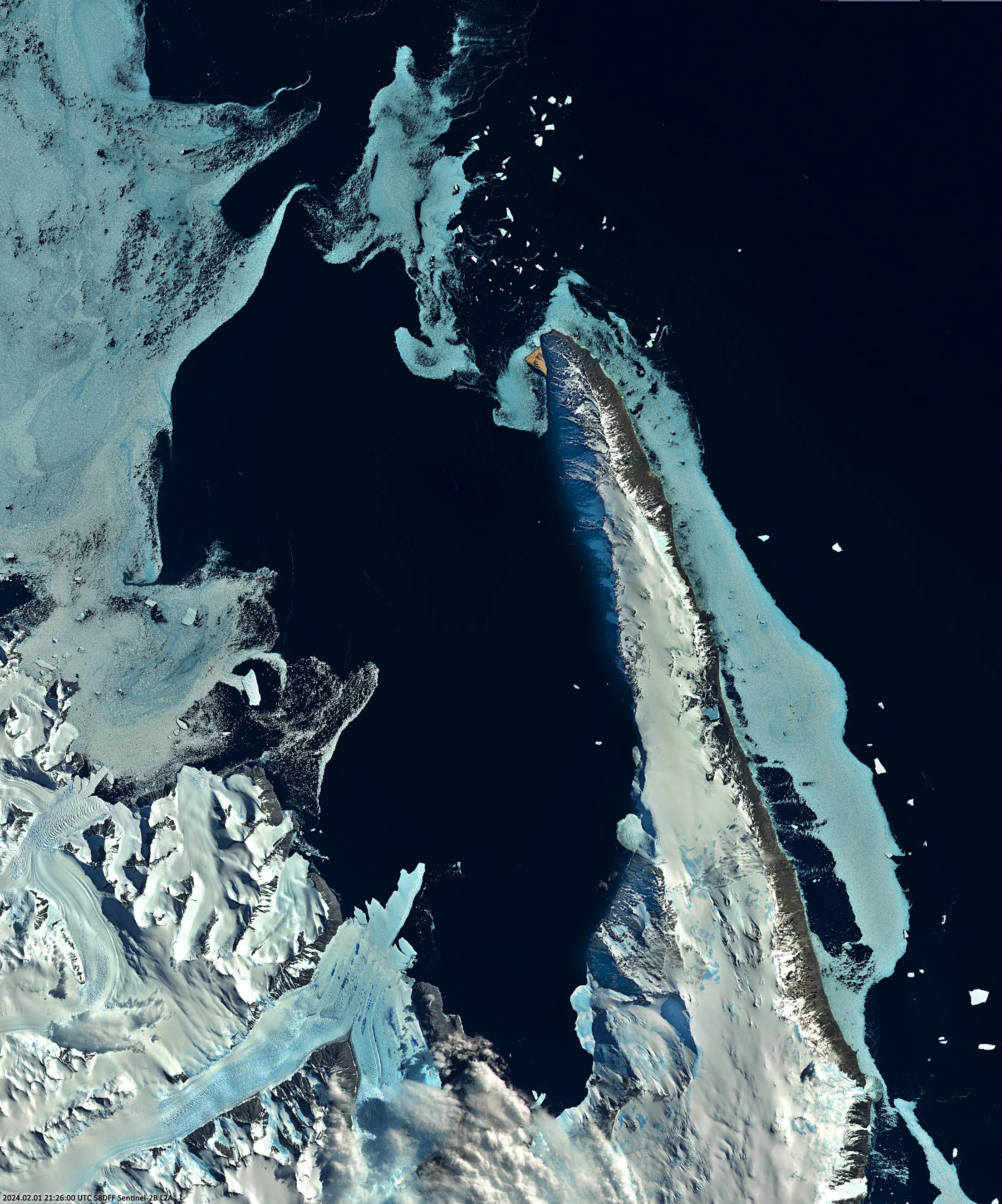
Cape Adare is a largely ice-free headland on the northeastern tip of the Adare Peninsula in Victoria Land, East Antarctica (Figure 1).
It marks the boundary between the Ross Sea to the east, Robertson Bay and the Somov Sea to the west, the Borchgrevink Coast to the south and east, and the Pennell Coast to the west. The Admiralty Mountains rise behind the cape. Cape Adare is of volcanic origin and consists of dark basalt. Broad, cone-shaped volcanoes rise gently over ridges to a height of about 2000 meters and are characterized by large calderas. Cape Adare was discovered by James Ross in January 1841 and is a Commonwealth reserve.
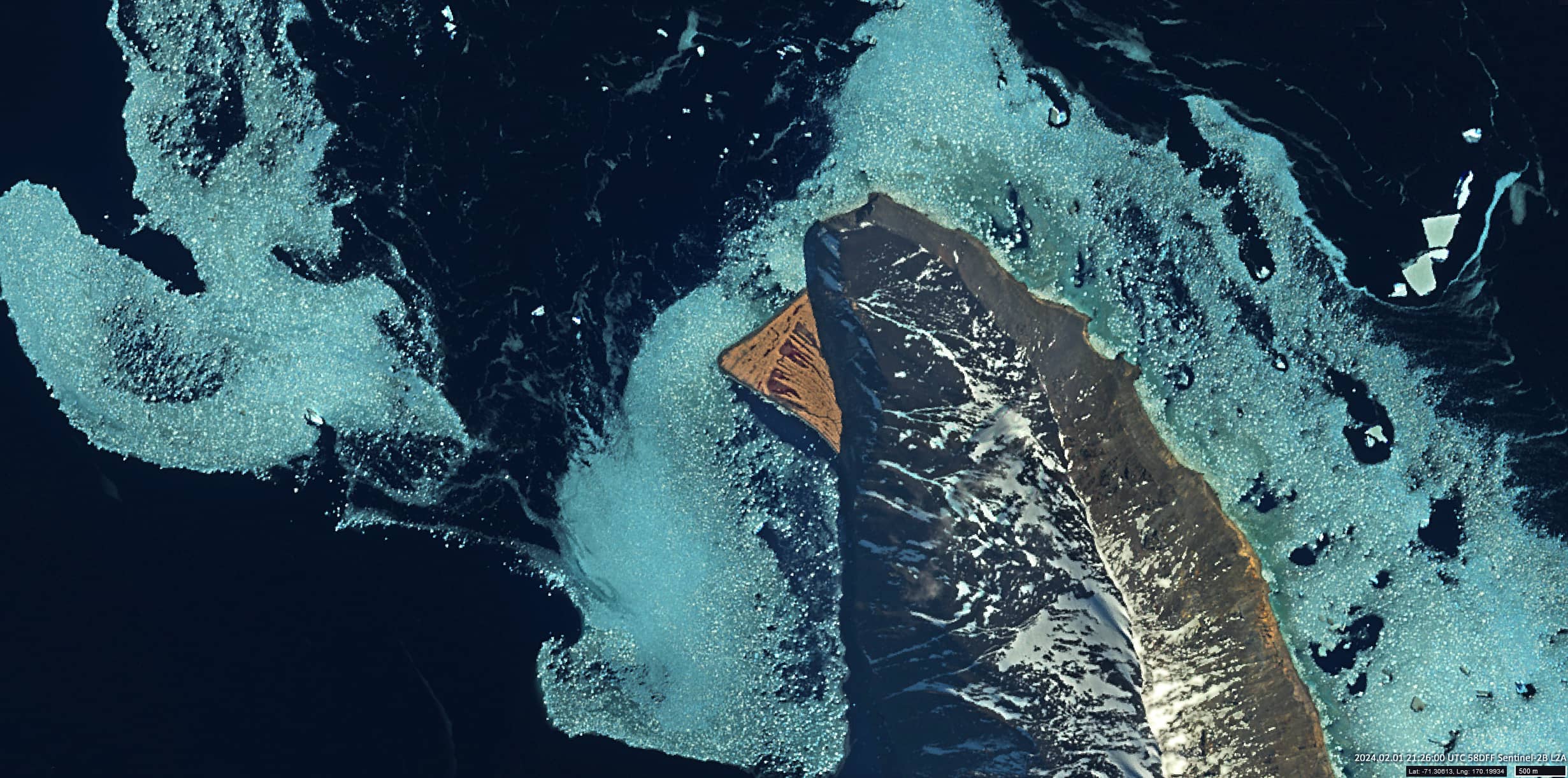
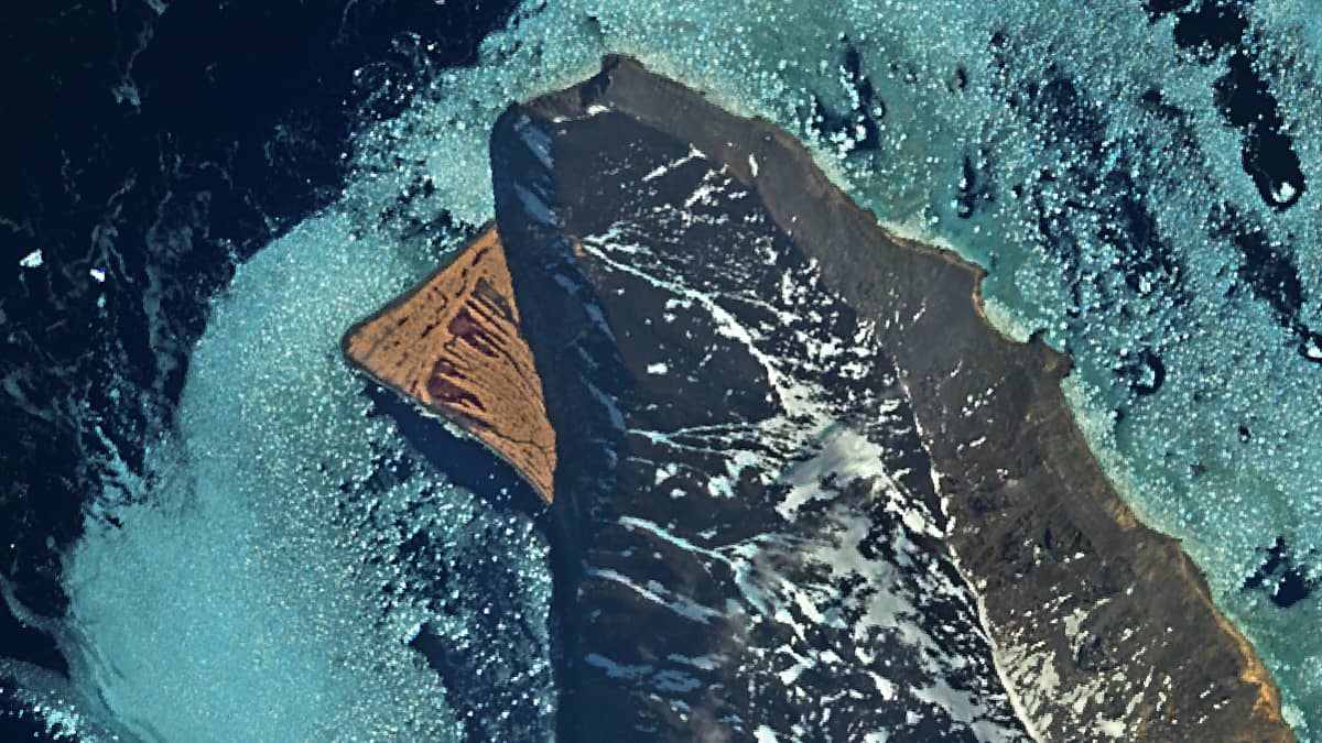
Ridley Beach, which is triangular in shape and approximately 1.9 kilometers long on each side, is located 1.5 kilometers south of Cape Adare on the west coast of the Adare Peninsula (Figure 2).
It consists of two groups of hills, several meters above sea level, separated by ditches. These groups are almost perpendicular to one another and were formed at different times. The hills, which run parallel to the coast of the peninsula, are probably moraines from the retreating ice sheet that once filled Robertson Bay. The beach is made up of gravel, mainly volcanic rock, but with many stones from the mainland.
It is also home to one of the largest Adélie penguin colonies in Antarctica. Hundreds of thousands of penguins nest not only on the flat peninsula, but also on steep cliffs up to several hundred meters high.
The first landing
Having decided to become an explorer, the Anglo-Norwegian Karsten Egeberg Borchgrevink, signed on as a sailor on the Norwegian whaling ship “Antarctica” and later became part of the crew of a rowing boat that landed on the shore of the cape (now Cape Adare) on the northern edge of the Ross Sea on 23 January 1895.
This was the first documented landing on the Antarctic mainland! (There are versions that the American whaler John Davis was the first to land on the coast of Antarctica – on the Antarctic Peninsula in 1821. Earlier landings of seal hunters and whalers cannot be ruled out, but they kept their routes secret.)
However, other researchers claim that New Zealander Alexander Francis Henry von Tunzelmann was the first person to set foot on the Antarctic mainland. Seven members of the “Antarctica” crew, led by expedition leader Henrik Bull, landed in a boat. They all landed within seconds of each other, but there is some dispute as to who touched the ground first. Some speculate that Tunzelman was the first to jump into the water and hold on to the boat to prevent it capsizing in the surf, while the others jumped off. The smart Borchgrevink took a few steps towards the shore and was the first to touch dry land.
The Antarctic Base
In February 1899, the British Southern-Cross-Expedition was founded by Borchgrevink at Cape Adare. It was the first Antarctic base, the first wintering station on the Antarctic continent, and it was from this “smelly, penguin-inhabited place” that the exploration of Antarctica began.
Two prefabricated huts were built on Ridley Beach from pine kits brought from Norway. A wooden frame covered with sealskins provided a protected passage between the houses and a storage shed. Each hut had an area of about 35 square metres. One was used for storage and the other for living. The hut was quite small for the winter life of 10 people, – 5.5 x 6.5 meters. Wool, fura and papier-mâché were used for insulation, and the small window was double-glazed. Both huts have survived the extreme conditions of Ridley Beach for over a century, making them some of the most durable constructions in Antarctica. The habitation hut is still in good condition even after 116 years.
The northern party of R. Scott’s 1911 British Antarctic Expedition also wintered on Ridley Beach near Borchgrevink’s hut. However, the buildings erected by this expedition have not survived.