"Dragon-Looking Cloud" Structure (DLCS)
The "Dragon Eye" structure was so called because I discovered this name
on the NASA
Visible Earth web page.
It would be natural to suppose that the warm streams of air go upward,
"breaching" a layer of stratocumulus clouds, where ice crystals fluffy
cloud with great albedo further (increasing in the height) appear.
At the same time the cold dry air moves downward, surrounding the warm
"column" along its perimeter and breaching the layer of stratocumulus
clouds from above, driving away clouds.
However the MERIS Level 2 data show that the upper board of the clouds
(the so called 'eye"), is not located over the upper boarder of the surrounding
cloud field.
It has been tried to solve this problem studying the shadows as the Sun
in polar latitudes is not too high in the sky and objects cast long shadows.
Unfortunately it did not bring good results, though no long shadows was
seen.
While exploring the structures tentatively called "Cloud Curls" (and
later "Dragon Eye") by means of the processed MERIS Level 2 data I paid
my attention to the unusual configuration of the upper board of the curls.
 As
the MERIS Level 2 shows, the structures are down-directed funnels and
the clouds located in center and underneath have great albedo. As
the MERIS Level 2 shows, the structures are down-directed funnels and
the clouds located in center and underneath have great albedo.
The examples are as follows:
Part "Cloud Curls"
-
20061224_25182.jpg
-
20060201_20514.jpg
-
20060131_20500.jpg
and also
-
20060104_20116.jpg
-
20050104_14891.jpg
-
20070210_25868.jpg
-
20050121_15134.jpg
-
20060120_20350.jpg
So it may be assumed that the situation is not always covered with
the model used to develop Level 2 data in which case the data do not reflect
the reality.
On the other hand, if it works in the right way, it is hard to explain
the phenomena I told you about. And I myself am not completely satisfied
with these reasons of my
own explanations.
Studying the "Dragon-Looking Cloud - Dragon Eye" structures I discovered
the same situation.
Here are the examples:
Part "Dragon-Looking Cloud"
-
20050105_14904.jpg
-
20070205_25798.jpg
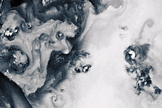
The structure could be rare observed above sea surface in Polar Regions.
The "Dragon Looking Cloud" Structures tentatively was called like this,
because they are often the neighbours of "Dragon Eye" structures. In addition
this kind of cloud with its chaotic, turbulent, irregular shape can remind
of dragon. Of course it is a very free definition, which does not base
on certain physical phenomenon.
The structure could be observed above cold water in Polar Regions.
The Coriolis Effect works relatively strongly in these widths. Vertical
air flows can be formed above the warm sea areas. In cooperation with
local winds many small vortices from small convective cloud cells can
develop there.
The neighbours of "Dragon Looking Cloud" Structures are quite often spacious
layers of stratocumulus clouds and "Cloud Curls" Structures.
"Dragon Looking Cloud" Structures are not seen frequently, though they
can be seen quite often.
|