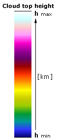
|
h max = 7÷16 km
h min ~= 0.2 km
The lower limit of a cloud top height registered by MERIS does
not change as a rule and remains at the level 0.2 km.
The upper
limit changes from 3 to 16 km.
However the order of false colours keeps the same when the images
and the upper limit change. |
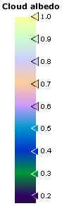
The
scale for the cloudy albedo remains permanent for all corresponding
images. |
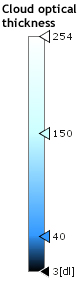
The
scale for the cloud optical thickness remains nearly permanent for all corresponding
images. |
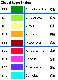
The
scale for the cloudiness type remains invariable for all corresponding
images. |